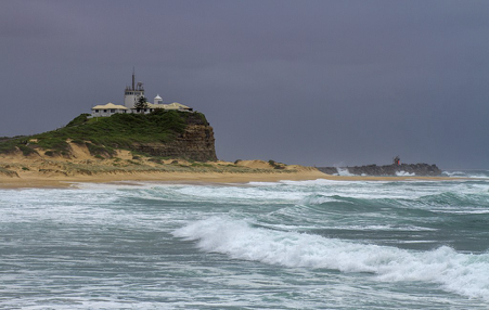
Nobbys Head and Mount Sugarloaf
Grade 2: Two distinctive but unnamed Cook Landmarks. Both worth exploring of you are in this area. Short walk to the summit of Mount Sugarloaf for extensive 360 degree views.
Situation: Newcastle, New South Wales
Coordinates (decimal):
Nobbys Head: 32.92 S 151.80 E
Mount Sugarloaf: 31.23 S 151.67 E
Aboriginal names:
Nobbys Head: Whibayganba
Mount Sugarloaf: Warrawelong
Endeavour Journal, 10 May 1770:
At Noon we were by observation in the Latitude of 32.53 S, Longde 208.00 West and about 2 Leagues from land which extended from N 41 E to S 41 W. A small round rock or Island laying close under the land bore S 82 West dost 3 or 4 Leagues… In the Latitude of 33.2 S a little way inland is a remarkable hill that is shaped like the Crown of a hatt which we passed about 9 oClock in the forenoon.
The ‘small rock or Island’ is Nobbys Head at the south of the mouth of the Hunter River at Newcastle, and the ‘remarkable hill that is shaped like the Crown of a hatt’ is Mount Sugarloaf (412m), 25km west of Newcastle and at the northern end of the Sugarloaf Range. Nobbys Head was an island, now joined to the main land by a causeway.
Maksym Kozlenko [CC BY-SA 4.0 (https://creativecommons.org/licenses/by-sa/4.0)], from Wikimedia Commons